Architecture
The Big Picture
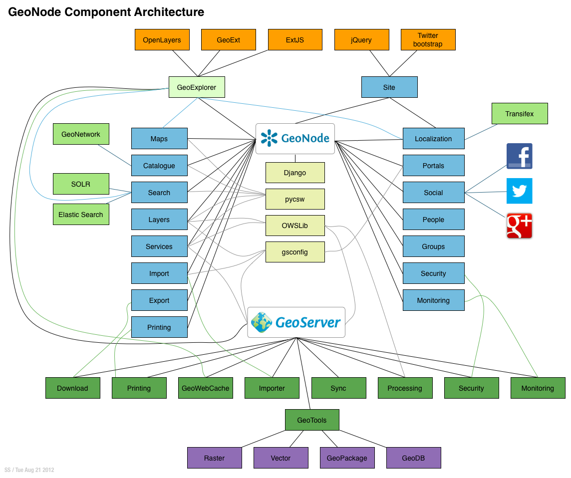
GeoNode Component Architecture
Django Architecture
www.djangoproject.com
MVC/MVT
- MVC
- Model, View, Controller
- MVT
- Model, View, Template
- Model represents application data and provides rich ORM functionality
- Views are a rendering of a Model most often using the Django template engine
- In Django, the controller part of this commonly discussed, layered architecture is a subject of discussion. According to the standard definition, the controller is the layer or component through which the user interacts and model changes occur.
More: http://reinout.vanrees.org/weblog/2011/12/13/django-mvc-explanation.html
WSGI
- WSGI
- Web Server Gateway Interface (whis-gey)
- This is a python specification for supporting a common interface between all of the various web frameworks and an application (Apache, for example) that is ‘serving’.
- This allows any WSGI compliant framework to be hosted in any WSGI compliant server.
- For most GeoNode development, the details of this specification may be ignored.
GeoNode and GeoServer
GeoNode uses GeoServer for providing OGC services.
GeoNode configures GeoServer via the REST API
GeoNode retrieves and caches spatial information from GeoServer. This includes relevant OGC service links, spatial metadata, and attribute information.
In summary, GeoServer contains the layer data, and GeoNode’s layer model extends the metadata present in GeoServer with its own.
GeoNode can discover existing layers published in a GeoServer via the WMS capabilities document.
GeoServer delegates authentication and authorization to GeoNode (see README).
Data uploaded to GeoNode is first processed in GeoNode and finally published to GeoServer (or ingested into the spatial database).
More: http://geoserver.org
GeoNode and PostgreSQL/PostGIS
In production, GeoNode is configured to use PostgreSQL/PostGIS for it’s persistent store. In development and testing mode, often an embedded sqlite database is used. The latter is not suggested for production.
- The database stores configuration and application information. This includes users, layers, maps, etc.
- It is recommended that GeoNode be configured to use PostgresSQL/PostGIS for storing vector data as well. While serving layers directly from shapefile allows for adequate performance in many cases, storing features in the database allows for better performance especially when using complex style rules based on attributes.
GeoNode and pycsw
GeoNode is built with pycsw embedded as the default CSW server component.
Publishing
Since pycsw is embedded in GeoNode, layers published within GeoNode are automatically published to pycsw and discoverable via CSW. No additional configuration or actions are required to publish layers, maps or documents to pycsw.
Discovery
GeoNode’s CSW endpoint is deployed available at http://localhost:8000/catalogue/csw and is
available for clients to use for standards-based discovery. See http://docs.pycsw.org/en/latest/tools.html
for a list of CSW clients and tools.
Javascript in GeoNode
- GeoExplorer runs in the browser and talks with GeoNode and GeoServer’s APIs using AJAX.
- jQuery is used for incremental enhancement of many GeoNode HTML interfaces.